
This ancient Donegal site is believed to have been the seat of the ruling kings of the area, known as the ‘Kingdom of Áileach’. Eógan Mac Néill of the Uí Néill dynasty (sons of Niall) is one of the earliest recorded kings here; he died in 465AD. The site is now a National Monument, and consists of a massive stone ringfort, thought to have been built by the Uí Néills in the seventh century. The nearby remains of a well and tumulus (burial ground) are believed to be even older, possibly dating back to the neolithic age.
From the top of Grianán of Áileach, you can take in a breathtaking, panoramic view of the beautiful Donegal countryside. In fact, on a clear day, it’s said that visitors can see an impressive five counties. This incredible spot is accessible all year long. is believed to have been the seat of the ruling kings of the area, known as the ‘Kingdom of Áileach’. Eógan Mac Néill of the Uí Néill dynasty (sons of Niall) is one of the earliest recorded kings here; he died in 465AD. The site is now a National Monument, and consists of a massive stone ringfort, thought to have been built by the Uí Néills in the seventh century. The nearby remains of a well and tumulus (burial ground) are believed to be even older, possibly dating back to the neolithic age.
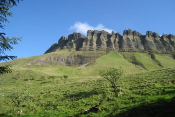
From the top of Grianán of Áileach, you can take in a breathtaking, panoramic view of the beautiful Donegal countryside. In fact, on a clear day, it’s said that visitors can see an impressive five counties. This incredible spot is accessible all year long. The Stone Fort of Grianán of Aileach is sits on a hilltop in Inishowen County Donegal. 250m above sea level, the stone fort was probably first built on an earthen rath. The view from Aileach is breathtaking. The glistening waters of Lough Foyle and Lough Swilly are clear, as is the form of the entire peninsula. A windy and exposed place, Grianán has been a silent witness to the history of Ireland. The origins of the Grianán of Aileach fort are dated back to 1700 BC. It is linked to the Tuatha de Danann who invaded Ireland before the Celts and built stone forts on top of strategic hills. They worshipped Dagda (the Good God) and he too is associated with the origins of Aileach. It was he who ordered the building of a stone fort to act as a burial monument to his dead son.
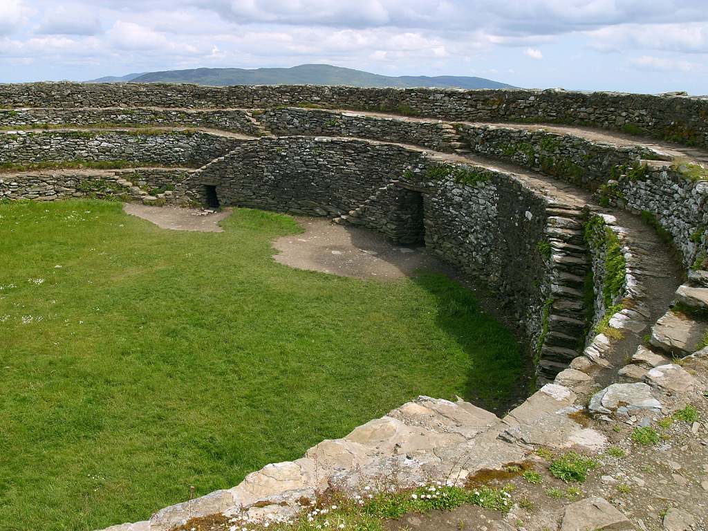
The round fort is built largely without mortar. The interior has three terraces and wooden structures were built against the terraces to provide accommodation. The outline of Bronze Age or Iron Age ramparts can be seen below the fort. Legend states that the giants of Inishowen are lying sleeping but when the sacred sword is removed they will spring to life reclaiming their ancient lands. Mr Walter Bernard of Derry restored the stone fort or cashel in the 1870's. It is the centrepiece of the site, 23m in internal diameter with walls measuring 5m in height and approximately 4m in thickness. The dry stonewalls contain two passages within them as well as terraces along their interior which would have allowed access to their summit.
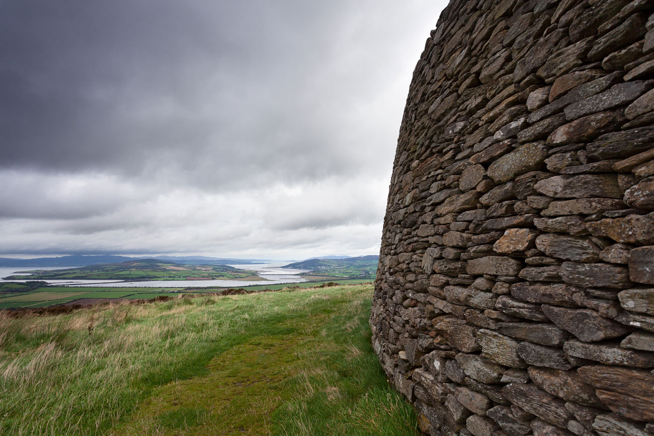
It is thought that St Patrick visited the site in the 5th century and baptised the local chieftain, Eoghan (from whom Inis Eoghan gets its name), here. The Grianán is located on the western edge of a small group of hills that lie between the upper reaches of Lough Swilly and Lough Foyle. Although the hill is comparatively not that high, the summit dominates the neighbouring counties of Londonderry, Donegal and Tyrone. Located at the edge of the Inishowen peninsula, it is 11.25 kilometres (7 mi) northwest of the ecclesiastical site of Derry. The histories of the sites are closely linked. There is much legend and historical material related to the Grianán of Aileach. The Irish annals record its destruction in 1101. The main monument on the hill is a stone cashel, restored in the nineteenth century, but probably built in the eighth century AD. The summit's use as an area of settlement may go back much further. A tumulus at the Grianán may date back to the Neolithic age. A covered well was found near the cashel in the early nineteenth century. George Petrie first surveyed the Grianán of Aileach in the 1830s. At this time the cashel was nothing more than a mere ruin. He gives a description of the hill and the monument. The eastern ascent of the hill is described as gradual but within 30 metres (98 ft) of the top, it terminated in a circular
apex.
An ancient road between two ledges of natural rock led to the summit. The cashel was surrounded by three concentric ramparts. Petrie suggests that, in the fashion of other monuments
of this type such as Emania, the whole hill may have been enclosed by many other ramparts. There is no physical or historical evidence for this. The ramparts that remained were made of earth and stone and follow the natural form of the hill with an irregular circular pattern. They ascend above each other creating levelled terraces. The circular apex of the hill within the outermost enclosure contains about 2.2 hectares (5.4 acres), within the second about 1.6 hectares (4.0 acres) and within the third about 4 hectares (9.9 acres). Currently, the innermost bank is very low, worn and heather-covered but traceable for almost its entire circuit. The other two banks are in a similar state but are untraceable for long sections. Between the inner most rampart and the cashel, the road dwindles in its width and curves slightly to the right. This "path" was strengthened on either side by walls. At the time of the survey only the foundation stones of these walls remained. Petrie's plan of the site shows a line of stones leading up to the
entrance. These are now gone.
Situated: From Letterkenny head east towards Derry on the N13 after 5 kilometres turn left at the roundabout, staying on the N13 heading for Inishowen. Shortly after Newtown Cunningham you will see Burt Castle on your left. Look out for a right turn for Grianan of Aileach. The monument is well sign-posted from this turn.